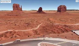
Anybody using the Google apps, Google Mymaps and Google Earth, for planning their touring routes? If you're not familiar with them, Mymaps lets you designate waypoints on a route you plan to take, and then the data from it can be exported to Google Earth where one can take a tour as if you're in a drone flying along the route. Fantastic way to preview a scenic tour using satellite imagery, particularly if it is a route you haven't taken before. I've attached an image from a tour preview I made for a trip to Monument Valley, Utah.
Route planning and preview using Google Apps
- Thread starter Drlonline
- Start date
Emira Forum Images


Emira Forum Images


Latest posts
-

-
 🏆 EPOTM Contest September 2025 - Emira Photo of the Month starts now!
- Latest: GrahamClark_60-68
-

-
